
The introduction of new Spotter buoys to measure wave height and, direction, and temperature in the sea off Victor Harbor in South Australia, provides a timely new resource to monitor fluctuating sea conditions and their effect on coastal environments.
As unusually warm ocean temperatures for this time of year have triggered peculiar and destructive brown foam (believed to be triggered by microalgal blooms) to be washed up along the southern coastline, the new buoys will provide crucial data to inform stakeholders and the public on changing ocean conditions.
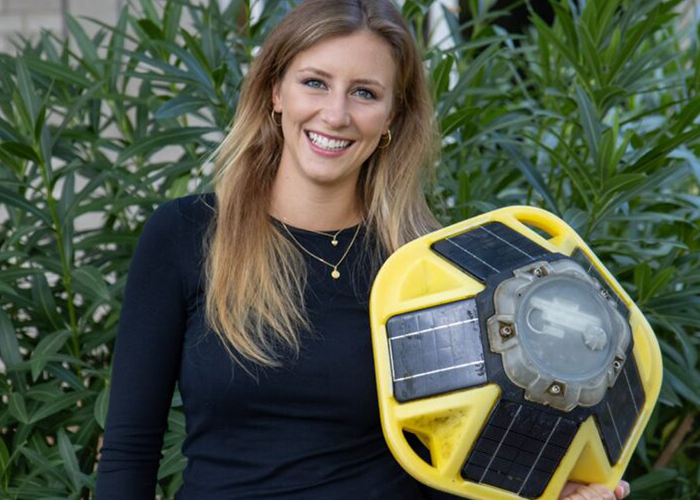
The buoys, released into Encounter Bay and the Southern Ocean in early March by Flinders University’s Associate Professor Graziela Miot da Silva and new PhD student Maya Lambert, working in conjunction with the South Australian Research and Development (SARDI) Oceanography team and Victor Harbor Council Coastal Surveillance Officer Bronson Symmonds, gather critical information on wave and ocean temperature changes driven by climate change.
The deployed buoys are Sofar Spotter metocean buoys, that collect and transmit accurate ocean data such as wave height, period and direction, estimates in wind speed and direction, plus sea surface temperature and barometric pressure in real-time via cellular data transfer.
“This will provide good baseline data about coastal waters that has been lacking, and there has never been a better time to have more information about this stretch of ocean,” says Miot da Silva, part of Flinders University’s Beach and Dune Systems (BEADS) Lab.
“There has been a significant gap in wave information available to researchers, managers, developers and policy-makers. These buoys will make a huge difference.”
The real-time wave data collected by this project will allow for the development of validated data-assimilating wave- and morphodynamic models to predict future changes in South Australia’s coastline, including climate change and sea level rise.
“The intent of the research is to find better ways to manage this coast and to mitigate the risk to private and public assets on the coastline,” says Professor Patrick Hesp, head of the BEADS Lab.
“The provision of accurate wave data is critical to improve understanding of variations in the hydrodynamic processes that shape coastlines, to inform best coastal management practices, drive the development of marine industries, and to promote and support tourism,” he added.
Data from the Spotter buoys, which will be maintained and processed thanks to a three-and-a-half-year Enterprise Industry scholarship funded by Victor Harbor Council and Flinders University to Flinders student Maya Lambert, will help local governments to forge better solutions for coastal protection.
Access to real-time wave data aids research and provides valuable information necessary for informing daily marine operations, such as dredging, navigation and sea conditions for commercial and recreational fishermen, plus search and rescue operations and water-based research and monitoring programs.
This work in Encounter Bay is a collaboration between Flinders University, SARDI (the research arm of the Department of Primary Industries and Regions), and several district councils will provide long-term monitoring with real-time wave and sea surface temperature data to better understand coastal processes in the region and help predict the future of the state’s coastlines.
The project builds on existing coastal research being done by Flinders University, SARDI, the Department of Environment and Water, and the Integrated Marine Observing System (IMOS) national Coastal Wave Buoys Facility, with data being gathered from an extended network of wave buoys extending across the state from Robe to Ceduna.
Access to this data is also freely available to the public through the www.sawaves.org website – a site that has quickly become popular with commercial and recreational marine users to check accurate wave conditions across the state.


