
The European Space Agency (ESA) says a new online platform designed to track settlement growth and assess exposure to natural hazards has been released, with the World Settlement Footprint (WSF) Tracker launched at an event at the World Bank headquarters in Washington, DC.
According to ESA, the WSF Tracker platform allows users to explore, analyse and download settlement data at 10 m resolution, with updates every six months. The platform is intended to support monitoring of settlement change over time, rather than relying on periodic “snapshot” comparisons.
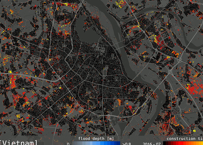
ESA said the WSF Tracker can monitor settlement growth continuously from 2016 to 2026, quantify the timing and pace of expansion at scales from global to city level, and identify hotspots and emerging settlement patterns. It also includes an option to combine settlement dynamics with hazard layers covering flooding, subsidence, seismic activity, extreme heat and cyclones, allowing analysis of how exposure evolves alongside urbanisation.
Fabio Cian, ESA representative to the World Bank, said the platform reflects collaboration between ESA, industry and development partners. “It demonstrates how ESA, industry and development partners can work together to co-design solutions that respond to operational needs, create public goods, and support long-term institutional capacity,” he said. “The combination of high spatial resolution, frequent updates and reduced lead time between observation and data availability makes the platform particularly relevant for operational and analytical applications. The fact that the platform is already informing World Bank activities highlights the importance of building solutions with a clear pathway to adoption, scaling and sustainability from the outset.”
ESA said the WSF Tracker builds on the World Settlement Footprint initiative led by the German Aerospace Center (DLR), which aims to map and monitor human settlements and characteristics of the built environment worldwide. The Tracker was developed jointly by DLR and MindEarth and co-designed with ESA and the World Bank, adding the capability to monitor settlement dynamics over time.
The release comes amid growing concern about how urban expansion intersects with climate and natural hazard risks. ESA said WSF Tracker data indicates cities and urban environments (excluding roads) cover 0.6% of Earth’s land surface as of January 2026, but house more than 57% of the world’s population. ESA also cited United Nations projections that the urban share of the global population will rise to 68% by 2050.
As development expands, ESA said, new construction is increasingly occurring in areas exposed to hazards including flooding, extreme heat, seismic risk, land subsidence and cyclones, raising questions for planning, infrastructure investment and disaster risk management. ESA said the WSF Tracker is intended to provide a more frequent and detailed evidence base to support those decisions when used alongside global hazard datasets.


